WHAT WE DO
geomatics
The Royal Institute of Chartered Surveyors defines geomatics as the science and study of spatially related information; particularly the collection, interpretation/analysis and presentation of the natural, social and economic geography of the natural and built environments. In simple terms this means measuring the world around us, whether manmade or natural, to produce maps. The discipline of geomatics is crucial as it provides the base for any development or redevelopment work involving land, structures or buildings.
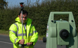
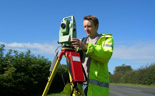
The areas of geomatics that Phase Site Investigations Ltd specialise in are topographic and land surveys. We utilise one-man total stations to measure the built and natural environment. These high-precision instruments are fully robotic and allow a survey to be carried out with a single operator.
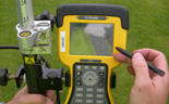
If the site conditions allow and it is a more cost-effective option then we also have the capability to carry out high precision real-time GPS surveys. We are also able to connect GPS systems direct to some of our geophysical survey equipment. On large open sites this allows us to increase the speed at which we can collect data whilst still maintaining a high degree of accuracy.
Normally we carry out topographic surveys as part of a wider service package, such as tying in topographic features to accurately locate utility apparatus or a geophysical survey grid, but we can provide them as a stand-alone service if required. We can also undertake setting-out services and if required can work with specialist companies to provide measured building surveys or 3D laser scanning.
Our surveying experience allows us to ensure that all of our non-intrusive surveys are located as accurately as possible. By carrying out a topographic survey ourselves or utilising existing survey data we are able to provide our survey results in an accurate scaled format that that is readily accessible and can be easily incorporated into existing site drawings or plans.